Me-Kwa-Mooks Park
Appearance
| Me-Kwa-Mooks Park | |
|---|---|
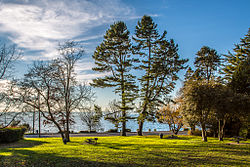
 View of the park looking out toward Puget Sound | |
 | |
| Type | Public |
| Coordinates | 47°33′48″N 122°24′13″W / 47.56333°N 122.40361°W |
| Area | 20.2-acre (82,000 m2) |
| Established | 1971 |
| Operated by | Seattle Parks and Recreation |
Me-Kwa-Mooks Park is a 20.2-acre (82,000 m2) public park located in the West Seattle neighborhood of Seattle, Washington, USA. Me-Kwa-Mooks is an Anglicized version of the Lushootseed word for Alki Point, sbaqʷabqs (pronounced SBAH-kwahb-ks), meaning "prairie point."[1]
Today's Me-Kwa-Mooks Park is land that was acquired by the Parks Department in 1971. The site was originally the homestead of the pioneers Ferdinand and Emma Schmitz. When all the Schmitz family died it became city land.[2]
In 1994, 4th and 5th graders from Pathfinder K-8 School helped make Me-Kwa-Mooks a park. In 2009, Pathfinder moved to Cooper Elementary School, a 10-year-old building on the other side of West Seattle, so they could no longer work on the park.

References
[edit]- ^ Waterman, T. T. (2001). sdaʔdaʔ gʷəɬ dibəɬ ləšucid ʔacʔaciɬtalbixʷ - Puget Sound Geographical Names. Seattle: Lushootseed Press. p. 65.
- ^ www.architectmagazine.com https://www.architectmagazine.com/project-gallery/me-kwa-mooks-net-zero. Retrieved 2022-07-06.
{{cite web}}: Missing or empty|title=(help)
External links
[edit]
